Earlier this week I've reviewed two free, online map collections. See "The Marshall Historical Maps Collection" and "Maps online from the New York Public Library". Today, I'd like to examine two of the map databases in Ancestry.com's collections.
Historic Land Ownership and Reference Atlases, 1507-2000
The source information for the Historic Land Ownership and Reference Atlases, 1507-2000 database identifies the source of the original data as Historic Map Works, LLC. This is an excellent collection of high resolution, full color cadastral maps. Cadastral maps, sometimes called land ownership maps, list the owners' or residents' names on the maps. The card catalog gives a name count estimate of 42,855 names. I think in actuality, this is the number of maps in this collection. The number of names may be much more since each cadastral map contains many names. If you have ancestors living in New England around the time of our country's first centennial, there's a good chance they're named in one of the Beers atlases in this collection.
I also enjoy these maps for the handiwork in their production. The color in these atlases was hand water-colored, making each map in each atlases absolutely unique. I've reproduced below the same detail from the map of Hamilton Town, Madison County, New York that I showed earlier in the week from the New York Public Library. Compare the two and see if you can see differences along the color edges. Can you imagine what it would cost today to produce hand-colored maps? Wow!
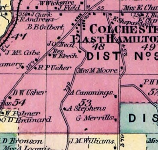
Compare this detail from a Madison County atlas map to the one from New York Public Library.
I've only had a little experience with atlases of federal land states in this time period. My experience there has been that names are not included. You'll have to look up a land description of your ancestors' property separately and then consult the map to see your ancestors' property in context. I have no experience with the southern state atlases so I looked at an example or two. It looked like the map coverage of the collection is not as good, but owner names were included on the maps I checked.
I absolutely love this collection and I think you will too.
U.S. County Land Ownership Atlases, c. 1864-1918
Prior to obtaining Historic Map Works' collection, Ancestry.com put together a similar map database from Library of Congress microfilm. The database, U.S. County Land Ownership Atlases, c. 1864-1918, is black and white since it is digitized from microfilm. This database is outclassed in pretty much every way by the Historic Map Works database.
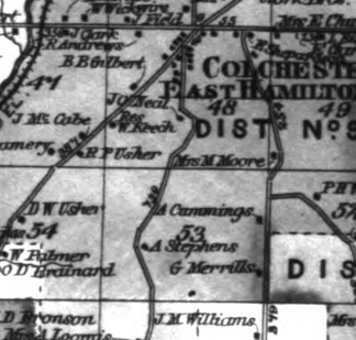
This detail covers the same area as the one above.
It appears from the card catalog that this collection contains 33,404 maps, almost 25% less than the Historic Map Works collection. But that doesn't mean every map in this database can be found in the Historic Map Works database. If you find a map in this collection that you can find in color on the previously mentioned websites and databases, you'll probably find the color version to be aesthetically superior. But if you can't find your map in color, you may find the map in this database to be more than suitable for your genealogical needs.
Thanks. I located the "family farm".
ReplyDelete